
Applied Imagery Quick Terrain Modeler 8.4.0 with Sample Data | 2.2 Gb
Product:Applied Imagery Quick Terrain Modeller
Version:8.4.0 build 82836 USA Edition * with Sample Data
Supported Architectures:x64
Website Home Page :
https://appliedimagery.com/Languages Supported:english
System Requirements:Windows **
Size:2.2 Gb
* It's the USA Version which got no restrictions compared the International Version (because of security laws)
Applied Imagery is pleased to announce the release of QT Modeler 8.4.0, which solves one of our users' biggest problems: access to geospatial data.
Our revolutionary new QT Data Explorer enables intuitive, fast, and interactive searching and downloading from online data repositories. QTM 8.4.0 also includes layer tree export to KMZ (Google Earth), upgrades to our HLZ tool, the ability to create your own stencils, search tool upgrades, a new hillshade lighting tool, and much more.
What's New QT Modeler 8.4.0
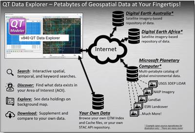
QT Data Explorer:
QT Data Explorer revolutionizes the search for online geospatial data by delivering a simple, yet powerful tool to interact with STAC API data repositories. Simply connect to a STAC API repository (e.g., Microsoft Planetary Computer), draw an Area of Interest on an interactive map, then start exploring the data that is available. You can discover unlimited types of data - LiDAR point clouds/DSM's, color imagery, vectors, Landsat imagery, etc., sift through it, then download what you need, load it into QTM, and start working with it!
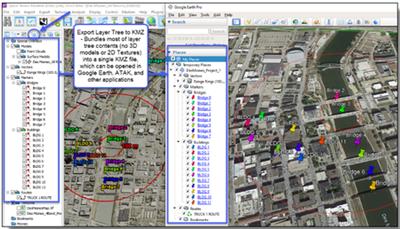
Export Layer Tree to KMZ:
QTM's new export layer tree to KMZ function exports all layer tree content into a single KMZ file that can be opened in Google Earth - or any software that can read KMZ. This can condense work that you've done in QTM (markers, routes, annotations, bookmarks, stencils) in a very compact format.
Note: 3D data and textures are not included in this KMZ export, but can be exported independently in many formats.
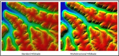
Multidirectional Hillshade:
QT Modeler's Multi Directional Hillshade enables the activating and setting of, three additional lighting sources to the main directional lighting. This allows for a fuller shading component to the visualization of your surface model data.
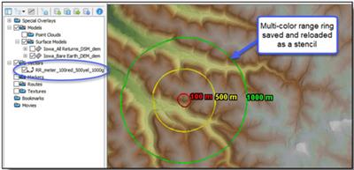
Annotation Upgrades - Make Your Own Stencils:
Stencils can now remember and honor color values, and you can create your own! Simply right click on any vector, Export > Save as Stencil. Then select that stencil whenever you need it in the future. This will make it much faster to create and reuse common vectors such as multi-color range rings.
Helicopter Landing Zone (HLZ):
We have added the number one requested HLZ upgrade: the ability to save/reload HLZ Presets. The HLZ upgrade in QTM v832 provided many more user settings, so users wanted an easy way to remember and reload those settings. There are several buttons at the top of the HLZ tool to facilitate this. In addition, HLZ now automatically creates a new Vertex Color layer every time the analysis is run (rather than overwriting).
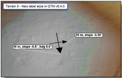
Terrain X:
Terrain-X, the tool that is used to mark local slopes and headings (very useful in annotating an HLZ), has gotten a cosmetic refresh. The lines and arrowheads are thicker, labels have caption offsets, and the primary arrow now will always point "downslope".
Model Search
Model Search now has a few more search parameters and capabilities:
- Inverse search (everything *outside* search area)
- Search Quadrants (search NE, SE, SW, or NW quadrants individually if desired)
- Added context menu option to remove items from list
Miscellaneous Tweaks and Enhancements:
- Layer Tree: Added ability to rename top level folders.
- Range Rings: No longer include decimal points in labels.
- Google Earth Sync: Now Includes stencils when syncing (previously only routes, markers, and range rings were automatically sent to GE).
- ATAK: No longer export GPX routes and points (only exports KML now).
- GRG: Tweaked code to ensure GRG X is *always* at the first visible gridline intersection.
- Measurement Vectors: Now use Caption Font Style.
- Measurement Line: No longer can place measurement line in minimap.
- Travel Route Analysis Tool: Virtual LOS shown in TRAT should reflect LOS colors.
- WMS failures should do a better job of presenting meaningful error messages.
- Workspaces now force a layer tree refresh after load.
- DEM Toolkit now loads source data in a background thread for better GUI updates.
- Virtual LOS - Added Sensor Checkbox and Button.
- Cut/Crop:
. Visible Points Cut/Crop should now honor PAT Masking
. Added new icons for Visible Points Cut/Crop
- Merge Vectors: Merged Vector should copy its style settings from the first vector in the merge list.
- DEM/Point Cloud Toolkits:
. Added option to simply COPY FILES
. Added context menu option to COPY FILES
- Contours: When generating contour line vectors, if index lines are not active all lines will be solid.
- Progress Bars: General consolidation/revamp of progress bar management
- KMZ :
. QT will now attempt to directly load KMZ imagery via GDAL.
. Added KMZ to most imagery file selection dialogs.
. Added wrapper to properly handle special characters when writing names in KML files.
- Gridlines Dialog can now be opened when no models are loaded.
- Infrastructure Tweaks:
. Updated to Proj 9.0
. Updated Aspose Cells (Excel) to 21.12.0
. Updated Aspose Slides (Powerpoint) to 22.4
. GDAL - Added support for LERC/ZSTD compression
. Updated to GDAL 3.5.0
. Updated to Curl 7.75.0 (OsGeo4)
. Updated to Expat 2.2.10 (OsGeo4)
. Updated to Xerces 3.2.3 (OsGeo4)
. Updated to Boost 1.74 (OsGeo4)
Bug Fixes v840:
- GRG: Fixed issues with proper management of Yellow X in variant coordinate systems.
- Workspaces: Fixed some weirdness with accumulating repeated file extensions in names of vectors on repeated.
- PowerPoint: Fixed double period in exported file name.
- Model Search: Fixed issue recognizing duplicate LAZ files.
- KML/KMZ:
- Movies: Fixed crash issue attempting to load non-QMV file as a QT movie.
- Search - - Should now properly remember search radius units.
- Horizon Analysis: Fixed improper unit conversion when generating Markers with units override.
- LAS/LAZ: Added some code to protect against bad LAS/LAZ.
- Workspaces: Fixed crash issue with auto-backup workspace.
- HLZ: Fixed crash when run on DEM data with empty rows.
- Gridlines: tweaked code making rendering slow when adding cross-CS gridlines to point clouds
- Textures: Fixed render clipping plane issue when in 2D mode with textures and deselected models.
- WMS: Tweaked XML file for ArcGIS to fix SSL issues
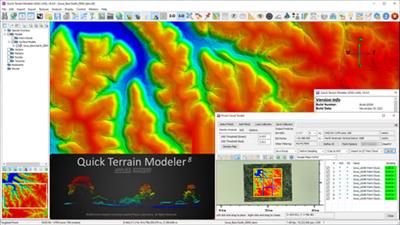
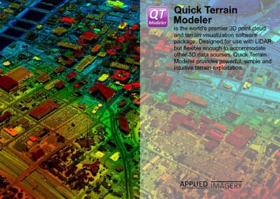
Quick Terrain Modeleris the world's premier 3D point cloud and terrain exploitation software package. Designed for use with LiDAR, but flexible enough to accommodate any 3D data source, Quick Terrain Modeler provides an easy to use software experience that allows users to work with huge 3D data sets, quickly analyze that data, and export a wide variety of export products - all with a minimum of training and experience.
Quick Terrain Modeler Tech Notes - Airborne and Terrestrial Mobile LiDAR
Brief overview of working with publicly available airborne LiDAR and mobile terrestrial LiDAR from Here Technologies
Applied Imagerywas founded in 2004 in Silver Spring, MD, a suburb of Washington, D.C., to commercialize software developed at Johns Hopkins University's Applied Physics Lab (APL). Our commercial, off-the-shelf (COTS) software, the Quick Terrain Modeler, is the world's premier 3D point cloud and terrain exploitation software package. Quick Terrain Modeler is focused on DoD and civilian applications and continues to evolve based on customer feedback. Of note to Government customers, Applied Imagery is designated as a small business and is the sole source for the Quick Terrain Modeler in the United States.


Links are Interchangeable - No Password - Single Extraction