Leica Hexagon GeoCompressor 2022 (16.7.0.1963) | 115.5 mb
Product:Leica Hexagon GeoCompressor
Version:2022 (16.7.0.1963)
Supported Architectures:x64
Website Home Page :www.hexagongeospatial.com
Languages Supported:english
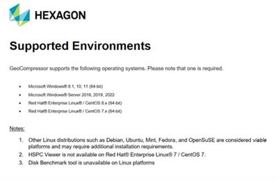
System Requirements:Windows *
Size:115.5 mb
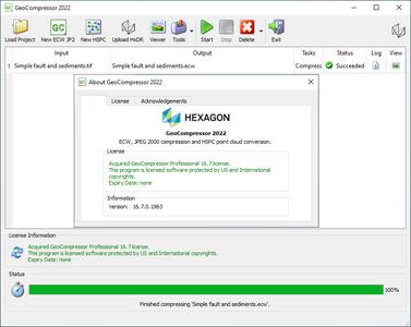
The Leica development team is pleased to announce the availability of GeoCompressor 2022, is a stand-alone data preparation tool to rapidly compress imagery data to ECW or JPEG 2000 file formats. This release extends this core capability to also cover a variety of user experience improvements, including regional localization support.
GeoCompressor 2022 also provides incremental performance improvements and bug fixes, valued by our Data Provider customers seeking to compress ever-growing project sizes on commodity hardware.
What's new in GeoCompressor 2022
- Compression performance gains of up to 30% with the latest ECW JPEG 2000 SDK.
- Added multiple language support to the GeoCompressor and Viewer user interfaces. Current supported languages are English, German, Korean, Spanish, French, Italian, Portuguese, and Simplified Chinese.
- Added "Gigapixel" field to raster properties panel in Viewer for extended user information.
- A map view for visualizing the input and output file footprints has been added to the image compressor wizard. Footprints can be selected and edited.
- Consolidated opacity mode and shapefile region selection to a single page in the image compressor wizard. Region selection (from shapefile) is now defined only once for both output extents and opacity generation.
- Optimized the default output extents when compressing with a region. Output is now clipped to the intersection of the image and the bounding box of the input region, potentially producing smaller files.
- JP2 SIZ marker is now consistent with the JP2 profile (J2P1) declared in the file type box.
- Added capability to geolink multiple images in MDI mode using screen or image space in GeoCompressor Viewer.
- Added XML metadata view to ECW JP2 layer properties in GeoCompressor Viewer. This is primarily for viewing the contents of the "GML in JP2" box.
- Added conversion of point clouds to Hexagon Smart Point Cloud (HSPC) format and removed the obsolete Hexagon Point Cloud (HPC) format.
- Added Upload to HxDR utility, to upload HSPC files (and other supported formats) to the Hexagon Digital Reality (HxDR) platform. Removed upload to Smart M.App Chest account capability.
- Added a new Disk Benchmark utility for system verification of disk read I/O performance.
- Added a new Calculate Checksum utility to aid in verifying file integrity

GeoCompressoris a high-performance geospatial image and point cloud compression application that allows you to access our unparalleled compression technology. Throughput in excess of 250 MB/sec can be seen on commodity hardware while processing terapixelsized images, making GeoCompressor the most highperformance mosaicking and compression tool on the market and in some cases, the only solution that is able to work with these data sizes.
GeoCompressor is a targeted application designed to address data provider pain points optimising processing workflows. This targeted niche allows us to optimise to a degree simply not possible with other more general geospatial software products.
Introduction to GeoCompressor
In this demo, we'll give you a quick overview of GeoCompressor as well as how to make an ECW file from multiple geo defaults
Hexagonis a global leader in digital reality solutions, combining sensor, software and autonomous technologies. We are putting data to work to boost efficiency, productivity, quality and safety across industrial, manufacturing, infrastructure, public sector, and mobility applications. Our technologies are shaping production and people-related ecosystems to become increasingly connected and autonomous - ensuring a scalable, sustainable future.

Links are Interchangeable - No Password - Single Extraction


