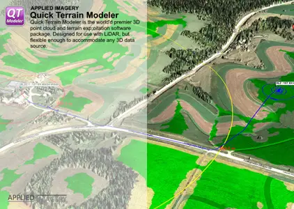
Free Download Applied Imagery Quick Terrain Modeler 8.4.3.1.1 Build 82946 | 4.1 Gb
Applied Imageryis pleased to announce the release ofQuick Terrain Modeller 8.4.3, which enables users to enhance their Geospatial products in a new and exciting way, which we call Geospatial Augmented 3D (GA3D).
Owner:Applied Imagery
Product Name:Quick Terrain Modeller
Version:8.4.3.1.1 (82946) USA Edition * with Sample Data
Supported Architectures:x64
Website Home Page :
https://appliedimagery.com/Languages Supported:english
System Requirements:Windows **
Size:4.1 Gb
* It's the USA Version which got no restrictions compared the International Version (because of security laws)
Data Explorer - More Versatile Than Ever!
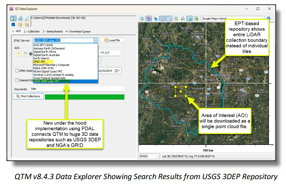
QTM's Data Explorer is now the best option for online data discovery and retrieval. The evolution of Data Explorer began as a STAC-based solution, but now also interfaces seamlessly with EPT-based point cloud repositories, including USGS 3DEP and NGA's GRID. Users can simply point to a repository from the QTM pulldown menu or from custom repository locations, all while using a friendly, map-based environment. Some distinctions between types of repositories:
-STAC:QTM's existing implementation enables exploration of enormous repositories of a wide variety of data types (point clouds, DSM/DTM's, imagery, etc.). Draw your Area of Interest (AOI) on the map, see what is available, and download as desired.
-EPT:Similar to STAC but focused exclusively on point cloud data. Users will discover entire collections, from which their AOI carves out a custom, single point cloud (see image below). If desired, this point cloud can be modified (e.g., downsampled, filtered) via QTM's Point Cloud Toolkit prior to download, potentially saving valuable download time and bandwidth.
-WMS (Web Mapping Server):While technically unrelated to Data Explorer, don't forget that newly downloaded 3D data can be supplemented with fresh 2D imagery and maps from a variety of public (e.g., Google Maps) and private (e.g., Maxar G-EGD/Digital Globe) sources, enabling rapid creation of integrated 3D scenes.
Close
LAS/LAZ Support - Unlimited Nonstandard Attributes
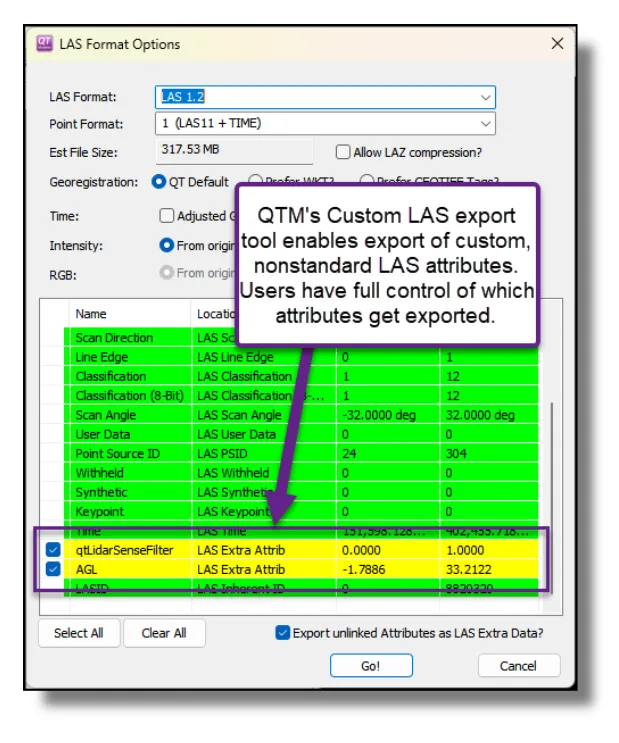
QTM v8.4.3 adds support for custom, nonstandard LAS attributes. This means that QTM-created point attributes such as Above Ground Level (AGL) height can be retained upon export and reused and/or shared with other users. Users have full control of which attributes get included in the export files.
Close
Export to ATAK - Support for COT2525 Markers
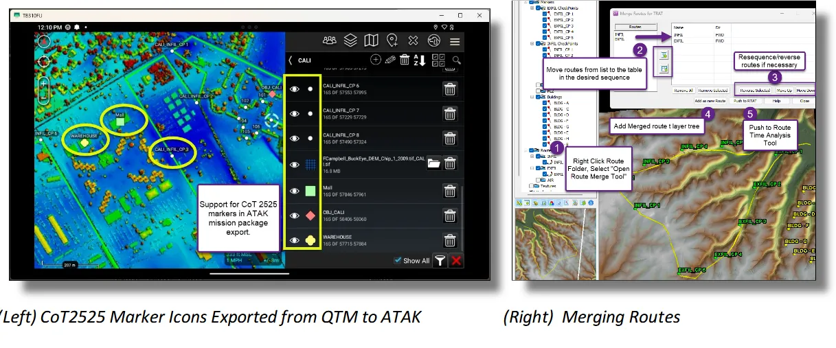
QTM now exports markers to ATAK as CoT 2525 icons. This means that QTM markers no longer appear as a pushpin. The default icon is the white Spotmap icon, but QTM will include a small library of other icons to choose from. All of this gets exported as part of the standard ATAK data package export.
Close
Combine Routes (Right Click Routes Folder)
QTM v8.4.3 adds the ability to merge multiple routes together. This will make combined route time analysis possible. For example, an Infil route could be merged with an Exfil route to analyze total travel time. Users can choose to export the combined route or to only use the combination for time analysis.
Close
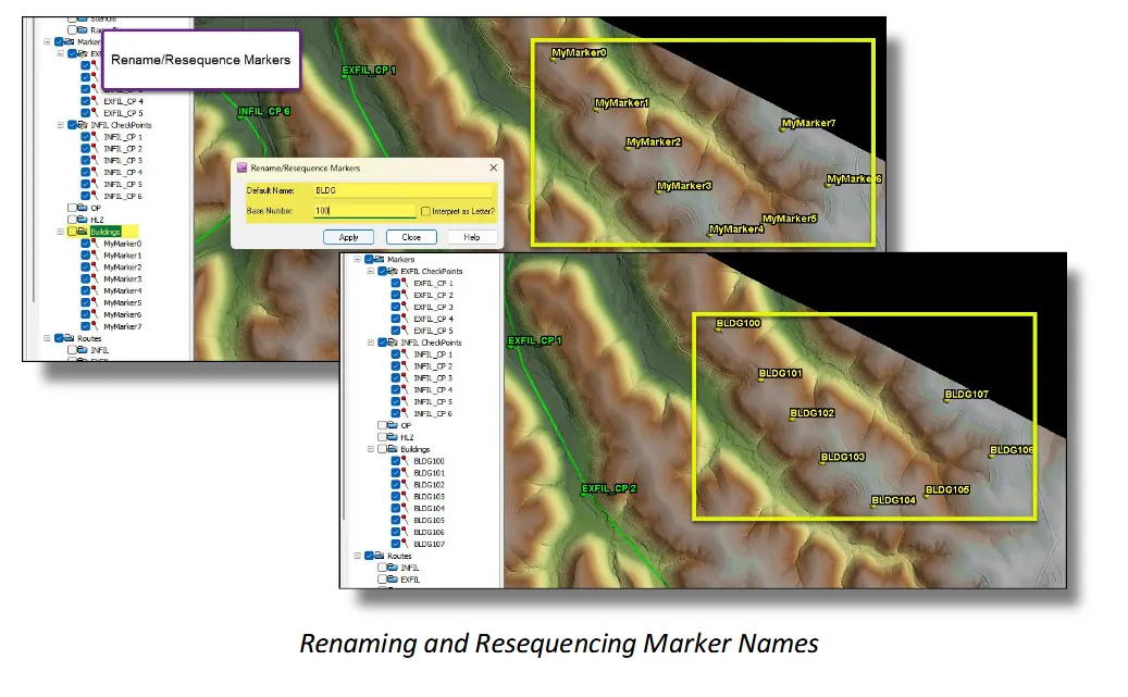
Marker Rename/Resequence (Marker Manager or Right Click Marker subfolder)
QTM v8.4.3 adds a very flexible and fast tool to rename and resequence markers. This can be very helpful in GRG creation, or any task that requires many markers with a numeric or alphabetical sequence.
Miscellaneous Tweaks and Enhancements v8.4.3:
- API:
. Implemented QT_PLUGIN_GET_DISPLAY_UNITS
. Implemented QT_PLUGIN_EXPORT_POINT_TO_LAS2 with support for Custom LAS/LAZ
. Implemented QT_PLUGIN_MODEL_GET_TRANSFORM/QT_PLUGIN_MODEL_SET_TRANSFORM
. Updated QT_PLUGIN_GET_DISPLAY_UNITS to include more info
. Implemented QT_PLUGIN_MARKER_UPDATE_AGL
. Fixed issue where MODEL_SAVE would pop dialog for name selection even if API supplies a filename
. Fixed issue properly encoding SRCIDX for multiple-file-models
. Fixed issue with QT_PLUGIN_POINT_DESCRIBE_SOURCE_FILE always returning the info for source "0".
- OBJ and Stencil libraries (GOV Version Only):
. Expanded OBJ file library to include more vehicles - including ships.
- Measurement Line - Added ability to CTRL+LCLICK add-and-move new nodes (like in route editing)
- Travel Route Analysis Tool (TRAT):
. Now updates OBJ heading on manually moving the slider
. No longer adds observer height to OP marker.
. Tweaked calculation of OBJ heading and updating of position during play
- Made consolidated progress bar for "Sampled Features Stats" and should pop Feature Manager after completion.
- HLZ Analysis: You can choose color for "Not Evaluated"
- Merge Models: When merging models with different QTA tables, QTM now gives you the options to keep all attributes by generating "blank" attributes for those models which are missing some.
- Added support for Rasterlite imagery.
- Geospatial Coordinate System (CS) Support:
. Should now do a better job of evaluating Cartesian CS for compatibility with other CS
. Added distance corrections for PseudoMercator/EPSG:3857
- Convert Model Type: Restored ability to resample QTT (Surface) models
- Marker icon window is now resizable
- Image and Model Search can now find MBTiles
- File Formats/Support Libraries:
. Implemented PDAL support
. Updated to latest FFMPEG
. Added support for rendering Movies to Animated GIF format
. Added ".kap" to default search extension list
. Upgraded to GDAL 3.9.0
. Added support for Spatialite
. Updated PROJ library
. Updated GDAL support files
. Updated to AWS C++ SDK v1.11.329
. Can now export imagery to Rasterlite
- Marker Icons: Vastly increased size of Image List for Icon Widget
- Tiling Toolkit: Now properly supports fixed length numbering
- Imagery/Textures:
. Added *.kap to image file type and search filters.
. Enabled compressed textures for OBJ models
. Enabled compression for regular textures as well
- INI File: Eliminated issue where QT appends "Do Point cloud normals?" entry to all of its INI files for no apparent reason
- Render Tiles to Garmin:
. Fixed issue with GE reading KMZ.
. Fixed issue with sometimes not all tiles rendering
- Model Search: Fixed issue with properly classifying BSB/KAP images
- DEM/Point Cloud Toolkit: Fixed undefined extra point in "export selection area to XXX"
- Selection Area: Fixed undefined extra point in "export selection area to XXX"
- Mesh Models: Fixed issue properly packing VBO data with delta relative to scale > 32767
- Fixed some issues passing GRID links from Explorer to Toolkits
- Fixed some issues with properly exporting custom CLASS
- Fixed issue with "render to Garmin KMZ" to rendering all tiles
- Fixed issue exporting to MBTiles from texture context menu
- Fixed silly toggle bug preventing QT from rendering QTC meshes.
- Fixed Tiling Toolkit un-necessarily popping Covert CS widget at times
- Markers/GRG: Current active marker folder should now take precedence over GRG folder when placing markers while the GRG Tool is open
- Fixed MBTiles and Rasterlite export support
- Export to registered image will no longer show Geodetic pixel scale in degrees.
- Texture registration now does a better job of calculating inverse matrices in cases (far north Geodetic) where the standard methods degrade.
- Fixed checks in file->options menu
- LOS GUI should now honor "reset on model load" setting
- Fixed issue with Route Time Analysis GUI being classed as globally always-on-top.
- Fixed issue where Icon Manager would quit upon encountering invalid or improperly sized icons
- Streaming WMS textures should now attempt to fix projection errors when pulling chips.
- Fixed some issues with properly calculating VLR count written into LAS/LAZ header.
- Fixed issue with certain vector formats importing with a total transparency
- Fixed bug preventing loading markers from reading Threat Dome info
- Fixed bug where WKT got corrupted if you repeatedly exported QTC to LAS
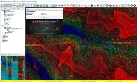
Quick Terrain Modeleris the world's premier 3D point cloud and terrain exploitation software package. Designed for use with LiDAR, but flexible enough to accommodate any 3D data source, Quick Terrain Modeler provides an easy to use software experience that allows users to work with huge 3D data sets, quickly analyze that data, and export a wide variety of export products - all with a minimum of training and experience.
Quick Terrain Modeler Tech Notes - Airborne and Terrestrial Mobile LiDAR
Brief overview of working with publicly available airborne LiDAR and mobile terrestrial LiDAR from Here Technologies
Applied Imagerywas founded in 2004 in Silver Spring, MD, a suburb of Washington, D.C., to commercialize software developed at Johns Hopkins University's Applied Physics Lab (APL). Our commercial, off-the-shelf (COTS) software, the Quick Terrain Modeler, is the world's premier 3D point cloud and terrain exploitation software package. Quick Terrain Modeler is focused on DoD and civilian applications and continues to evolve based on customer feedback. Of note to Government customers, Applied Imagery is designated as a small business and is the sole source for the Quick Terrain Modeler in the United States.
Rapidgator
AppliedImageryQuickTerrainModeler8431182946.html
Fileaxa
9lt2e.Applied-Imagery-Quick-Terrain-Modeler-8-4-3-1-1-82946.part1.rar
9lt2e.Applied-Imagery-Quick-Terrain-Modeler-8-4-3-1-1-82946.part2.rar
TakeFile
9lt2e.Applied-Imagery-Quick-Terrain-Modeler-8-4-3-1-1-82946.part1.rar.html
9lt2e.Applied-Imagery-Quick-Terrain-Modeler-8-4-3-1-1-82946.part2.rar.html
Fikper
9lt2e.Applied-Imagery-Quick-Terrain-Modeler-8-4-3-1-1-82946.part1.rar.html
9lt2e.Applied-Imagery-Quick-Terrain-Modeler-8-4-3-1-1-82946.part2.rar.html
Applied Imagery Quick Terrain Modeler 8.4.3.1.1 Build 82946 (x64) Torrent Download , Applied Imagery Quick Terrain Modeler 8.4.3.1.1 Build 82946 (x64) Crack Download , Applied Imagery Quick Terrain Modeler 8.4.3.1.1 Build 82946 (x64) Patch Download , Applied Imagery Quick Terrain Modeler 8.4.3.1.1 Build 82946 (x64) Serial Keygen Download
